screencapture freemalaysiatoday category nation 2024 08 27 the hows and whys of sinkholes 2024 08 28 07 38 46

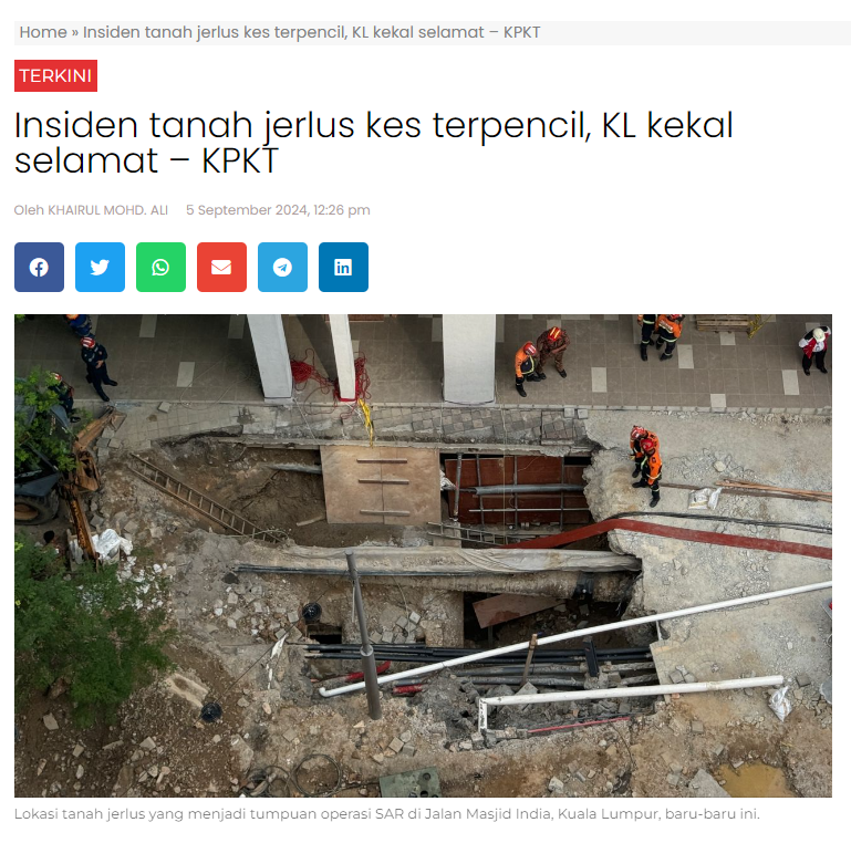
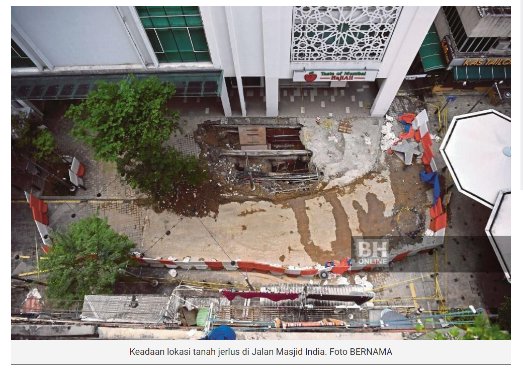
PETALING JAYA: On Aug 23, tragedy struck a visiting Indian national when she fell into a sinkhole that suddenly emerged along Jalan Masjid India, Kuala Lumpur.

The victim, identified as Vijayaletchumy, 48, had been walking on a concrete path outside Malayan Mansion when an 8m-deep sinkhole suddenly opened up and swallowed her alive.

Relentless search and rescue efforts have followed but the victim has yet to be found. Meanwhile, a wastewater expert has expressed fears that the victim is unlikely to have survived the high speeds at which water flows along the sewer lines.

How do sinkholes occur?

Sinkholes occur when an underground area can no longer accommodate the weight of its surface terrain. Simply put, these cave-ins are caused by erosion occurring beneath ground level.

This phenomenon usually takes place in areas where the surface rock comprises limestone or other forms of carbonate rock, salt beds and other materials capable of being naturally dissolved by groundwater.

As flowing water slowly chips away at subterranean foundations and destabilises the bedrock, hidden new caves emerge. These may collapse, creating sinkholes.

Natural and human factors

Underground erosion may arise both naturally or as a result of human activity.

The movement of water is a ubiquitous natural force in our world. It not only shapes landscapes visible to us, such as karst pinnacles and sea stacks, but also creates hidden underground rivers and caves.

Limestone terrains are particularly vulnerable to water erosion. Rainfall absorbs carbon dioxide from the soil before converging with the underground water, turning it slightly acidic.

This waterflow erodes the limestone sub-terrain and creates a network of cavities and voids. The US state of Florida, which has a geographical terrain primarily composed of limestone, is particularly prone to cave-ins.

Many sinkhole accidents are also attributable to rapid urbanisation.

For example, drought and high groundwater withdrawals may reduce the buoyancy of an area and trigger the sinking of sub-terrain areas into cavities. Similarly, changes to groundwater composition due to the introduction or removal of waterflows may flush out looser materials and precipitate sinkholes.

Faulty underground water pipes may also give rise to deadly urban sinkholes. Even a slight gap between these pipes is capable of introducing a large amount of water into adjacent soil, dislodging and eventually causing the subsurface to become unstable.

Despite the growth of cavities beneath the ground, no obvious signs of instability tend to appear above it.

With many of our utility pipes placed directly below ground, the paving of roads and pathways often acts as a bridge above sinkholes, hiding insidious voids below.

If a cavity is not discovered and resolved in time, the surface is likely to eventually give way and swallow everything above ground.

Early detection?

Although the existence of sinkholes underground is usually not apparent, several subtle signs may hint at a possible collapse of the sub-terrain.

Cracks in a foundation, an inability to close doors and windows properly, and the appearance of ground cracks in circular patterns are all tell-tale signs of ground instability which may point to the potential emergence of a sinkhole.

Since the tragic event on Friday, the government has advised the Kuala Lumpur City Hall (DBKL) and all utility companies to carry out a mapping of all underground utilities in an attempt to ascertain the state of the terrain below so that further untoward incidents can be avoided.

Other notable sinkhole incidents

One of the most well-known sinkhole accidents took place in Guatemala 14 years ago. On May 30, 2010, a giant sinkhole appeared without warning in Guatemala City, the Central American country’s capital.

The monstrous cavity, measuring 20m wide and 90m deep, swallowed a three-storey factory and its security guard. It was reported that the sinkhole occurred due to a combination of causes.

Subterranean stability in the area had been undermined both by natural causes in the form of a tropical cyclone and a volcanic eruption, and as a result of human activity, arising from sewer pipe leakages.

Sinkholes in natural habitats have sometimes also created astonishing natural sights.

For example, the Great Blue Hole, off the coast of Belize, has turned into a popular scuba diving destination. Recording a 300m width and 135m depth, the marine sinkhole was once a limestone cave system before the ocean rose.

Screenshot 2024 08 28 072915

Perkataan ‘geobencana’ menjadi sebutan seluruh rakyat Malaysia susulan kejadian wanita warga India terjatuh dalam tanah jerlus berhampiran Masjid India, Kuala Lumpur.

Masyarakat terutamanya para pelajar mula mencari-cari maklumat mengenai ‘geobencana’ yang dikatakan mengakibatkan kehilangan nyawa, kemalangan jiwa, kerosakan harta benda dan ekonomi serta boleh menjejaskan kualiti alam sekitar.

Berdasarkan pencarian maklumat oleh Sinar Bestari, geobencana atau dipanggil fenomena geobencana merupakan salah satu tajuk dalam mata pelajaran Sains Tingkatan Satu.

Ia terdapat pada Bab 9: Bumi dengan sub tajuknya Fenomena Geobencana.

Menurut buku rujukan Focus Sains Tingkatan 1, geobencana bermaksud bencana alam yang melibatkan proses geologi (sains tentang asal usul, sejarah, struktur dan komposisi bumi serta kaji bumi).

Fenomena geobencana boleh berlaku di mana-mana tempat dan pada bila-bila masa sahaja.

“Setiap tahun, geobencana menyebabkan banyak kematian, kecederaan dan kerosakan harta benda di setiap negara.

“Oleh itu, sains dan teknologi memainkan peranan yang semakin penting dalam menguruskan geobencana,” catat buku tersebut.

Satelit boleh menawarkan data yang tepat, kerap dan hampir serta merta di sebarang kawasan di bumi.

Apabila bencana berlaku, pengesan jarak jauh seperti satelit adalah satu cara untuk melihat apa yang berlaku di bumi.

Peralatan seperti seismometer digunakan untuk menyukat pergerakan bumi termasuk gelombang seismik yang dihasilkan oleh gempa bumi, letusan gunung berapi dan punca-punca seismik yang lain.

Selain itu, sistem amaran awal juga telah diwujudkan untuk memberi amaran kepada penduduk tempatan apabila geobencana dikesan.

Sistem amaran ini melibatkan penggunaan siren, telefon bimbit dan juga pengumuman melalui televisyen supaya masyarakat boleh membuat persediaan menghadapi kesan yang lebih teruk.

Kesan geobencana

Kesan negatif geobencana amat buruk terhadap kehidupan manusia.

Antara kesan-kesanya adalah;

1) Membawa kerugian besar kepada negara dan individu.

2) Menjejaskan aktiviti kehidupan individu atau masyarakat setempat yang menjadi mangsa dan turut memberikan impak sosial serta emosi kepada mereka.

3) Menjejaskan kesihatan mangsa di mana geobencana boleh menyebabkan kekurangan air bersih dan mangsa mudah terdedah kepada pelbagai jenis penyakit.

4) Memberi kesan kepada kemusnahan flora dan fauna.

5) Impak kepada sumber bekalan makanan di mana ia tidak dapat dihantar ke kawasan bencana kerana berlaku kesulitan seperti sistem perhubungan dan pengangkutan yang rosak. Situasi ini menyebabkan mangsa berada dalam keadaan kelaparan.

Screenshot 2024 08 28 072006

PETALING JAYA: In light of incidents involving sinkholes, a special committee that includes geologists, engineers, surveyors and town planners must immediately be set up to improve hazard management, said geologist and Universiti Malaysia Kelantan Geoscience Department lecturer Prof Dr Hamzah Hussin.


“While the Mineral and Geoscience Department is responsible for geohazards, forming a special committee would provide a more comprehensive approach to addressing such hazards,” he told theSun.

He said there is no detailed research being conducted by any government agency on the possibility of further sinkholes occurring in the Klang Valley and such research is focused in Gua Musang, Kelantan, which is located in a limestone area.

He said such studies are only carried out by contractors before developing major construction projects.


“A comprehensive geological study of the surface and subsurface area needs to be conducted urgently at high risk areas, with the findings incorporated within any design by a geotechnical engineer to ensure public safety.”


According to a research journal titled “Integration of Geoscience Information for Disaster Resilience in Kuala Lumpur, Malaysia”, only 20% of the city is highly suitable for development and not prone to climate hazards.

About 80% of the land area in Kuala Lumpur has medium to high ground constraints, including around 25% of the city area that is susceptible to landslides and floods.


“Over millions of years, acidic rainwater has worn away the limestone bedrock on which the city is built, creating a large network of underground cliffs, cavities and cracks that can range from small to massive in size.


“The size of subsurface openings varies due to limestone dissolution. For instance, the massive surface opening in Batu Caves can be seen but the huge cave system at the subsurface level is unexplored and its danger is unknown.”


Hamzah said cases of sinkholes appearing in the Klang Valley are few and within a limited area.


“This is normally caused by technical errors, such as leaking underground pipes and utilities or below-ground infrastructure construction.


“The sinkhole disaster in Guatemala in 2010 was 40m wide. It sucked down houses and killed three people after a major rainstorm. No tunnelling was ever involved, so if a similar sinkhole happens in Kuala Lumpur, it would be catastrophic.”


He said as a worst case scenario, a building could collapse if the sinkhole is large enough and although a national hazard identification study has been conducted, it only focused on landslides and debris flow.


Society for Engineering Geology and Rock Mechanics Malaysia president Dr Goh Thian Lai said sinkholes are often associated with post-construction maintenance as they are caused by the rapid lowering of the groundwater table and ground vibration.


“It is also caused by human activities, including piling works, quarrying, major construction or seismic activity. The Jalan Masjid India case in Kuala Lumpur is an anthropogenic sinkhole, which is caused by environmental changes and driven by human actions rather than natural processes.


“Detecting potential sinkholes involves field identification and the use of geophysical methods. Once potential sinkholes are identified, engineering measures are implemented to prevent subsequent consequences.”


He said geologists assess the risk of sinkholes in a given area by identifying signs of distress, such as tension cracks and early stages of subsidence.


He said the land on which KLCC and the Petronas Twin Towers are built is safe because these issues were addressed during construction.


The towers were shifted 60m to the Kenny Hill formation, which is not limestone, to avoid complex limestone or karst-related problems.


“The contractors also treated underlying limestone cavities. Nonetheless, authorities need to investigate if early signs of subsidence or large tension cracks have occurred near KLCC to prevent potential issues.”


Screenshot 2024 08 28 071241


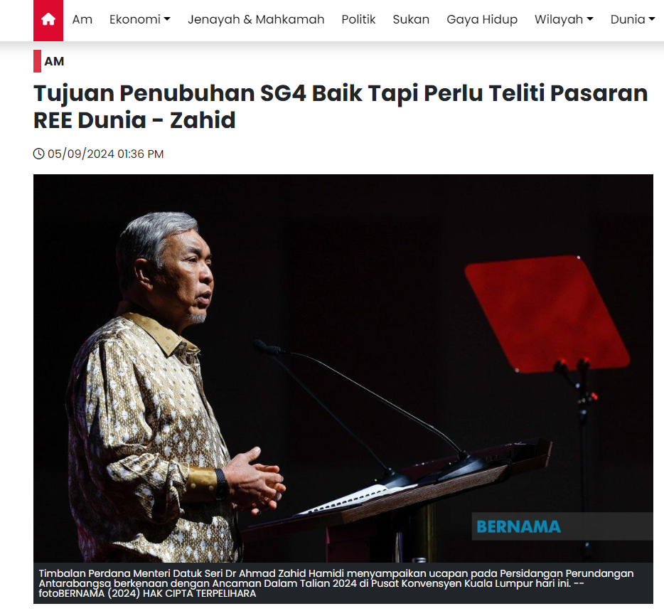
IPOH, 27 Ogos (Bernama) -- Kerajaan Persekutuan setakat ini tiada sebarang perancangan untuk menguruskan hasil unsur nadir bumi bukan radioaktif (NR-REE) termasuk melalui syarikat berkaitan kerajaan (GLC).
Menteri Sumber Asli dan Kelestarian Alam Nik Nazmi Nik Ahmad berkata pihaknya kini hanya dalam perbincangan melibatkan kerangka industri REE sebagaimana yang dihasratkan oleh Perdana Menteri Datuk Seri Anwar Ibrahim sebelum ini supaya negara tidak sekadar menggali, tetapi turut menjual bahan mentah. "Saya ingat Perak dah lalui proses itu sebelum ini sebagai pengeluar timah dan sebagainya, kita nak seperti dalam industri minyak, kita gali dan juga proses di negara ini, jadi dapat pulangan kepada negara.


"Jadi tentang soal untuk tubuhkan GLC dan sebagainya, tidak timbul buat masa ini walaupun ada dicadangkan di perbahasan Parlimen. Kita bergerak mengikut kerangka Perlembagaan dengan mineral selain daripada minyak dan gas terletak di bawah kerajaan negeri," katanya pada sidang media dekat sini hari ini.


Beliau berkata demikian ketika diminta mengulas sekiranya terdapat rancangan untuk menubuhkan GLC bagi menguruskan hasil NR-REE di negeri terlibat.


Ditanya jika terdapat kekhuatiran hasil NR-REE mungkin diuruskan GLC, Nik Nazmi menjawab: "Tiada kekhuatiran itu."


Julai lepas, Menteri Besar Perak Datuk Seri Saarani Mohamad pada persidangan Dewan Undangan Negeri Perak berkata kerajaan negeri akan memastikan NR-REE kekal milik kerajaan negeri dan tidak akan diuruskan oleh GLC.


- BERNAMA

Screenshot 2024 08 26 094027

KUALA LUMPUR: Datuk Bandar Kuala Lumpur Datuk Seri Dr Maimunah Mohd Sharif berkata tidak ada bukti kukuh yang boleh menyokong dakwaan bahawa bandar raya ini tidak selamat untuk diduduki seperti laporan yang ditularkan oleh media sosial.

Maimunah berkata Kuala Lumpur telah lama dibangunkan dan dakwaan bahawa ia tidak selamat untuk pembangunan perlu disertakan dengan bukti dan kajian yang kukuh.

“Saya berpendapat Kuala Lumpur telah lama dibina dan selama ini ia selamat. Oleh itu kalau nak katakan tidak selamat mesti ada bukti kukuh dan kajian terperinci.

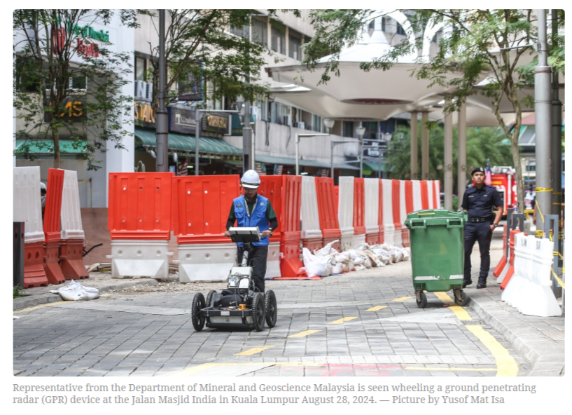
“Berikutan itu kami telah wujudkan pasukan petugas termasuk Jabatan Geologi dan Jabatan Kerja Raya untuk melihat serta kaji keadaan ini, namun kalau dilihat daripada keadaan semasa Kuala Lumpur masih selamat kecuali ada bukti kajian,” katanya dalam sidang media di Jalan Masjid India di sini hari ini.


Hadir sama Timbalan Pengarah Jabatan Bomba dan Penyelamat Malaysia (JBPM) Kuala Lumpur Rozihan Anwar Mamat, Ketua Polis Daerah Dang Wangi ACP Sulizmie Affendy dan Ketua Pegawai Eksekutif Indah Water Konsortium (IWK) Narendran Maniam.


Beliau berkata pasukan itu daripada Dewan Bandaraya Kuala Lumpur (DBKL), Polis Diraja Malaysia (PDRM), Jabatan Mineral dan Geosains Malaysia (JMG) serta Jabatan Kerja Raya (JKR) dan telah diaktifkan.

Maimunah berkata hasil mesyuarat penyelarasan bersama pelbagai agensi yang berkaitan hari ini, beliau memberi jaminan situasi sekitar Jalan Masjid India dan Kuala Lumpur amnya adalah terkawal serta selamat untuk dikunjungi.

Sebelum ini tular di Facebook hantaran yang dimuat naik oleh seorang aktivis alam sekitar pada 2015 yang mendakwa tempat paling tidak selamat di Malaysia adalah Kuala Lumpur dan berpotensi berlaku ‘giant sinkhole’ pada bila-bila masa.

Hantaran itu antara lain menyebut 40 hingga 60 peratus dasar Kuala Lumpur adalah batu kapur dan pembangunan tanpa henti dengan sistem saliran yang tidak tersusun boleh menyebabkan kejadian itu lebih cepat berlaku.


Adakah halaman ini membantu anda?

Invalid Input
Invalid Input
Invalid Input