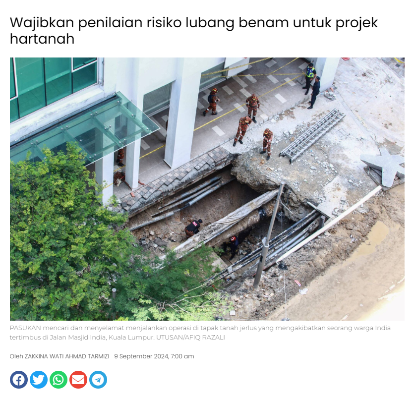
screencapture malaymail news malaysia 2024 09 09 how can you tell if a sinkhole is forming heres what to do if you spot one 149741 2024 09 10 08 40 15

KUALA LUMPUR, Sept 9 — Have you ever wondered if there is anything you can do before a sinkhole forms or collapses? Especially after the sinkhole incident at Jalan Masjid India in Kuala Lumpur where a tourist fell into one when the ground suddenly gave way?

In an interview with Malay Mail, Prof Jeffrey Chiang Choong Luin, president of the Institution of Engineers Malaysia (IEM), listed “tell-tale signs” of potential sinkholes, such as ground depressions, fallen trees, tilted buildings, cracks in buildings and concentrated water flow.


Chiang explained that ground depressions might indicate unstable or eroded soil due to prolonged water damage. He warned that such signs might be dismissed as poor workmanship when they could signal deeper issues like soil erosion.

If signs of a potential sinkhole are detected, Chiang advises notifying local authorities like Kuala Lumpur City Hall (DBKL), which oversees public infrastructure. He said sensors can also be used to monitor hotspots for sinkholes by detecting sudden ground changes or depressions.

The Malaysian Geotechnical Society (MGS) told Malay Mail that sinkholes can sometimes form without visible signs.

“Detecting sinkholes can be very challenging as it could happen without any signs on the surface beforehand. If there are signs such as surface depressions or leaking utilities, mitigation measures can be taken earlier,” the professional association for geotechnical engineers said in an email interview.

MGS said detection of leakage from underground pipes, which can cause soil erosion and potentially lead to sinkholes, falls outside their scope and is best addressed by maintenance specialists.

MGS also said the DBKL Task Force — which it is part of — will propose measures to prevent sinkholes from happening again once the root cause of the Jalan Masjid India sinkhole is identified.

MGS advised the public to report any signs of sinkholes to local authorities. It indicated that strengthening pavements, roads, and buildings in the affected area can be considered after the investigation concludes.

Strengthening works involve improving soil and infrastructure around sinkholes, while mitigation works address the underlying causes of sinkholes to prevent a recurrence, MGS said.

Chiang noted that buildings are generally safe due to sound foundations designed to support heavier loads, and that the focus should be on strengthening roads and pavements that have shallower foundation bases and are more vulnerable.

He stressed the importance of mapping high-risk areas and updating utility maps for effective strengthening and mitigation.

He urged authorities to use available technologies, such as sonar wave and geophone mapping, to accurately assess ground conditions and enhance sinkhole prevention efforts.

He said reliable and updated information is crucial for managing and preventing sinkholes in the future.


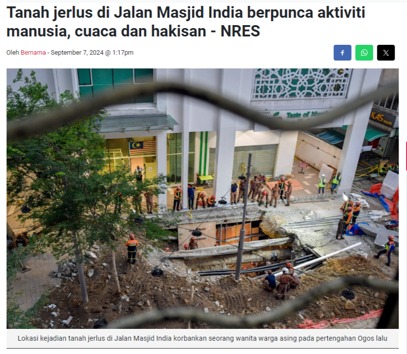
screencapture malaymail news malaysia 2024 09 09 whats next for the jalan masjid india sinkhole hint dont close it up yet 149390 2024 09 09 08 58 28

KUALA LUMPUR, Sept 9 — Now that the search and rescue operation for a tourist who fell into the sinkhole at Kuala Lumpur’s Jalan Masjid India has ended and moved to the search and recovery phase, what’s next? Will the cordoned-off sinkhole be closed up now, for example?

Engineering groups which spoke to Malay Mail said that the focus will be on investigating why the sinkhole happened, instead of closing it up immediately.

The Malaysian Geotechnical Society (MGS), which is a professional association for geotechnical engineers with about 200 members and also a part of the Kuala Lumpur City Hall’s (DBKL) task force on the Jalan Masjid India sinkhole, said a detailed investigation is needed first.

“The immediate next step is to conduct a detailed Geotechnical assessment to understand the extent of the sinkhole and the underlying cause. Closing up the sinkhole without addressing the root cause could lead to recurring issues.

“If the sinkhole is a result of a compromised drainage or sewage system, a comprehensive overhaul of these systems may be necessary to ensure the integrity accordingly. DBKL has already set up a Task Force to look into this matter and the Malaysian Geotechnical Society (MGS) is part of this Task Force Team,” the MGS said in an email response to Malay Mail's questions.

The Institution of Engineers Malaysia’s (IEM) president Prof Jeffrey Chiang Choong Luin said the sinkhole at Jalan Masjid India cannot be closed up now, as a thorough investigation has to be carried out there first to examine the structure of the ground underneath and find out why the sinkhole happened.

“One has to be aware that the ground underneath the collapsed pavements has been there for many years, presumably with many laid and over-laid service pipes, utilities, sewerage etc which is currently still serving the community in the vicinity.

“The opened-up sinkhole could be a good starting point for authorities to carry out in-depth investigation on what has transpired, and how such collapsed incidents can be prevented in similar spots nearby. It is still premature for us to make comments without proper investigation carried out yet,” he also told Malay Mail in a recent interview.

Chiang said the authorities will have to take a long-term view on how to resolve this matter and to alleviate the concerns of the public, and that the authorities will be the ones to make the call on the next steps.

“They will be the agency to decide whether to repair and to close up the collapsed sinkhole; or whether the services and utility underground on site need to be overhauled,” he said.

“IEM as an engineering professional institution do have experts among our 50,000 members, and we stand ready to assist the Authority in carrying out investigation and to propose and implement improved system to monitor and to map out hotspots in the KL city areas which are deemed to be of high risk,” he added.

So, which area needs to be cordoned off?

Asked whether there is a need for the nearby shops and area around the sinkhole at Jalan Masjid India to be cordoned off, Chiang said it is “necessary precautionary measure” to cordon off the hazard areas surrounding the sinkholes formed there “to safeguard the nearby shops, owners, workers and shoppers”.

“I think if you are the owner of the shop in the vicinity, your first concern would be personal safety and the wellbeing of other people nearby. The dangers here are that the risk of further sinkholes could occur in another nearby spot. Hence, it makes sense for authorities to take such precautionary measure. Yes, no doubt business operations will be affected, but human lives are so much more precious,” he said.

MGS said “public safety is of utmost importance, and it is prudent to conduct thorough safety checks in the vicinity of the sinkhole of Jalan Masjid India”, adding that the cause of a second sinkhole which appeared near to the first one there “shall also be quickly identified”.

“To be cautious, the area along the alignment of the utilities should be cordoned off for safety checks. While some checks might be conducted without restricting public access, more thorough investigations may require cordoning off the area to prevent any accidental harm to the public or workers,” MGS said, adding that the DBKL taskforce which it is part of will be providing technical recommendations on this matter.

But when asked if this means the cordon could possibly include buildings in the Jalan Masjid India, MGS said: “It is not necessary to include buildings and shops and walkways unless there are clear signs of instability or are deemed at risk.”

Asked whether the cordon or barriers should be around the two sinkholes only or if those would be a starting point, MGS said this would depend on the situation:

“Initially, cordoning off should focus on the areas around the first and second sinkholes to ensure public safety. Depending on the findings, it might be necessary to expand the cordoned area to include wider areas if they are deemed at risk”.

Asked if it would be feasible and doable to eventually widen the safety checks such as to the whole downtown Kuala Lumpur, MGS suggested a targeted approach: “Widening safety checks to the entire downtown Kuala Lumpur may be impractical. However, it would be prudent to identify areas of concern and then perform detailed safety checks on those areas.”

When asked if surrounding areas near Jalan Masjid India might be at risk and how the public would know which area nearby is safe, MGS pointed to the need for the investigation to be completed first: “A thorough investigation shall be carried out to identify the root cause of the issue. Clear communication from authorities will help the public understand the risks and safety measures being implemented by the relevant agencies.”

With the investigation on the Jalan Masjid India sinkhole still going on, MGS advised against speculation: “It is important for the media not to speculate on the causes of such incidents, as this might cause unnecessary chaos and fear among the public.”

MGS said prevention measures can be suggested after the investigation finds out why the sinkhole at Jalan Masjid India happened.

On September 1, national news agency Bernama reported Kuala Lumpur Mayor Datuk Seri Maimunah Mohd Sharif as saying that recovery and reconstruction covering 200 metres of the affected area at Jalan Masjid India is expected to take between three to six months.

She also said there would be checks on the underground utility systems including to inspect for any pipe leakages, while the Department of Minerals and Geoscience would provide detailed technical reports and information on soil stability around the sinkhole.
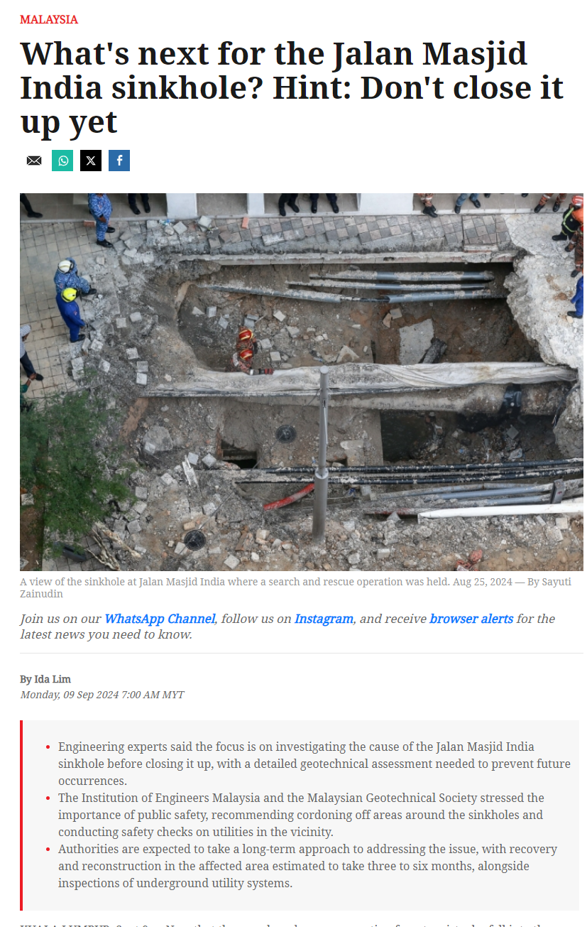
Screenshot 2024 09 09 084733

LUBANG benam adalah isu geologi yang serius yang boleh memberi kesan besar kepada infrastruktur bandar dan nilai hartanah.

Ia sering disebabkan oleh aktiviti manusia, seperti pengambilan air bawah tanah yang berlebihan, pengurusan perparitan yang lemah dan perancangan bandar yang tidak mencukupi.

Pendekatan proaktif yang melibatkan penilaian risiko yang menyeluruh, pemantauan berterusan dan pendidikan awam adalah penting dalam mengurus dan mengurangkan risiko ini.

Sehubungan itu, Presiden Pertubuhan Arkitek Malaysia (PAM), Prof. AR Adrianta Aziz berkata, pembukaan lokasi baharu harus melibatkan tinjauan geoteknikal yang terperinci untuk menilai kestabilan tanah dan potensi risiko.

“Kerajaan atau pihak berkaitan perlu mewujudkan Prosedur Operasi Standard (SOP) baharu untuk pembangunan hartanah harus merangkumi penilaian risiko lubang benam secara mandatori, pemantauan berkala terhadap paras air bawah tanah, dan pelan tindak balas yang kukuh sekiranya berlaku kejadian di masa hadapan.

“SOP ini perlu dikuatkuasakan ke atas semua pembangunan baharu dan sedia ada,” katanya ketika dihubungi Utusan Malaysia.

Jelas beliau, kerajaan dan pemaju harus menjalankan penilaian geologi yang segera dan menyeluruh di kawasan yang terdedah kepada kejadian lubang benam.

“Mereka juga perlu melabur dalam penambahbaikan dan penyelenggaraan infrastruktur untuk menangani punca-punca asas, seperti sistem perparitan yang lemah atau kebocoran air.

“Kempen kesedaran awam dan kemas kini berkala mengenai langkah keselamatan boleh membantu meyakinkan pemilik hartanah dan pembeli. Selain itu, pemaju perlu mengguna pakai dan menguatkuasakan kod bangunan yang lebih ketat yang mengambil kira risiko geologi,” katanya

Sementara itu, Perunding hartanah dan Naib Presiden IQI Realty Sdn. Bhd., Muhazrol Muhamad berkata, pembeli boleh mengurangkan risiko dengan membeli hartanah di lokasi yang dipercayai, daripada pemaju yang mempunyai reputasi baik atau bangunan yang sudah ada rekod prestasi yang kukuh.

“Kami juga menggalakkan pembeli untuk menjalankan pemeriksaan kualiti binaan sebelum membeli hartanah bagi memastikan ia bebas daripada kecacatan besar.

“Pembeli juga boleh mempertimbangkan untuk menggunakan khidmat penyelia bangunan, walaupun ia bukanlah satu servis yang popular di Malaysia dan tiada undang-undang yang mewajibkannya.

“Ini adalah langkah proaktif yang boleh memberikan jaminan tambahan terhadap kualiti dan keselamatan hartanah yang dibeli,” katanya. – UTUSAN

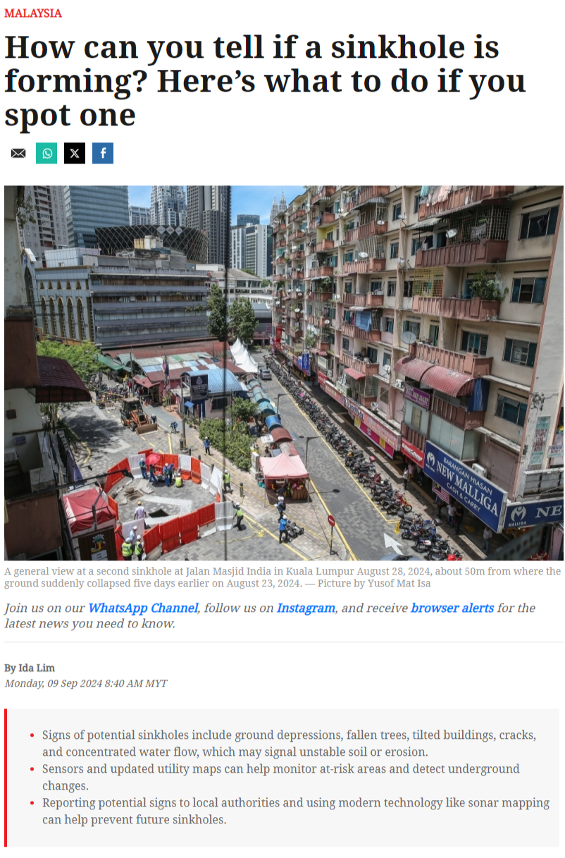
Screenshot 2024 09 09 083959

KUALA LUMPUR: Siasatan oleh pelbagai agensi terhadap kejadian tanah jerlus di Jalan Masjid India di ibu kota ini, mendapati insiden itu berlaku akibat antropogenik (aktiviti manusia), cuaca dan hakisan lapisan tanah tambak bawah permukaan kawasan terjejas.

Kementerian Sumber Asli dan Kelestarian Alam (NRES) memaklumkan, satu laporan teknikal hasil siasatan berkaitan geologi dan struktur bawah permukaan akan disediakan kumpulan Task Force Struktur Tanah Masjid India yang diterajui Dewan Bandaraya Kuala Lumpur (DBKL) dalam masa tiga bulan.

"NRES melalui Jabatan Mineral dan Geosains Malaysia (JMG) telah membantu dalam siasatan bawah permukaan kawasan kejadian tanah jerlus di kawasan Jalan Masjid India yang membabitkan seorang wanita warga India.


"Siasatan JMG menggunakan peralatan Ground Penetration Radar (GPR) bagi mendapatkan gambaran strata geologi dan sistem utiliti bawah permukaan kawasan kejadian bagi tujuan proses pemulihan menyeluruh oleh pihak bertanggungjawab," menurut kenyataan itu, yang turut menyatakan bahawa Kuala Lumpur adalah selamat untuk dihuni.

Bagi perancangan masa panjang, NRES memberitahu pemantapan terhadap aspek pemantauan, penyelenggaraan, prosedur dan kaedah penyiasatan bawah permukaan meliputi struktur binaan bawah tanah, dapat mengenal pasti dan mengelak sebarang ancaman tanah jerlus dan lubang benam yang mungkin berlaku.

NRES berkata, JMG sedang menambah baik data bawah permukaan kawasan Lembah Klang yang meliputi 10 pihak berkuasa tempatan (PBT) melalui Projek Pemetaan Geologi Sub-Permukaan Greater KL bagi melengkapkan maklumat sedia ada mengenai keadaan bawah permukaan Kuala Lumpur yang telah dijalankan di bawah projek 3DKL.

"Dari segi geologi, batuan dasar di Kuala Lumpur didasari sejumlah anggaran 30 peratus batu kapur dan 70 peratus terdiri daripada batuan granit serta batuan metasedimen iaitu Formasi Kenny Hill, Syis Hawthornden dan Syis Dinding.

"Manakala kawasan tanah jerlus adalah didasari batuan syis, filit dan kuarzit Formasi Kenny Hill," menurut NRES.

Pada 23 Ogos lepas, seorang wanita dikenali sebagai G.Vijaya Lakshmi berasal dari Kuppam, Andhra Pradesh, India hilang selepas terjatuh ke lubang sedalam lapan meter di Jalan Masjid India.

Operasi mencari dan menyelamat (SAR) wanita berkenaan tidak berhasil selepas sembilan hari dijalankan sebelum ia dihentikan sepenuhnya pada 31 Ogos lalu, selepas pihak berkuasa mengambil kira pelbagai faktor keselamatan terhadap pasukan operasi SAR. – BERNAMA

Did this page help you?

Invalid Input
Invalid Input
Invalid Input